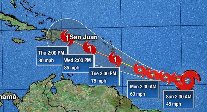
Forecasters on Sunday evening upgraded to a tropical storm warning the tropical storm watch that came into effect for St. Vincent and the Grenadines earlier that day.
A tropical storm warning means that tropical storm conditions are imminent within the warning area, generally within 36 hours.
Prime Minister Ralph Gonsalves is slated to chair a meeting of the National Emergency Council in Kingstown at 7 p.m. in preparation for the possible impact of the cyclone.
At 5 p.m. Tropical Storm Dorian was centred near 11.5 North 54.2 west or about 480 miles (approx. 770km) east-southeast of St. Vincent. Maximum sustained winds are now near 50 mph (85km/h) with movement towards the west (280 degrees) at 14 mph (22km/h) and a minimum central pressure of 1003mb (29.62 inches).
A general westward motion is expected to continue on Sunday with a turn toward the west-northwest on Monday. On its present forecast track, the centre of the system is expected to pass near or over St. Vincent early Tuesday morning.
Sustained surface winds between 58 to 70 mph (93 to 113km/h) with higher gusts are expected to spread across St. Vincent and the Grenadines early Tuesday morning, persisting into the afternoon.
In addition, pockets of moderate to heavy showers and thunderstorms are expected to move across the islands from early Tuesday morning. Rainfall accumulations of at least 3 to 5 inches (75 to 125 mm) are possible with isolated higher amounts. As a result, some flash flooding is likely in low-lying areas. Residents are urged to be on the alert and take all necessary precautions.
Large easterly to southeasterly swells of 2.5 to 3.5m (8 to 12ft) are also forecast to accompany the system. Low-lying coastlines around the islands will be particularly vulnerable at times of high tide. Large waves and dangerous rip tides can be expected. These will create unsafe conditions for small-craft operators and fishermen.
Consequently, a high-surf advisory and small-craft warning will be in effect from noon on Monday until 6 p.m. Tuesday. Sea-bathers and other users of the sea are also advised to stay out of the water.
A small-craft warning means that, in this case, wind-speeds of 50 to 60 knots (93 to 113km/h) and/or seas equal to or greater than 3m (10ft) will be affecting the marine area.
A High-Surf Advisory is issued when breaking wave action poses a threat to life and property within the surf zone.
High tides are expected around: 1:27 a.m. and 1:37 p.m. on Monday and 2:20 a.m. and 2:24 p.m. on Tuesday.
The next advisory will be at 11 p.m. today, Sunday.


Ya Mang