By Observer
In our previous article, we asked what exactly is the ULP government’s policy on sand mining, and in that piece, we pointed out that Jomo Thomas seems to be the one echoing the loudest concern over the dredging of sand at Argyle. We must, however, also acknowledge that of Andrew Simmons, PhD on this issue. I listened to an interview with him on Boom FM. What I gathered most from what he said is that there is a sort of sand barrier in the bay that runs from an area outside of Biabou down to somewhere off Brighton. That sand barrier acts like a defensive back wall, so that the coastal areas along that entire coastline are spared the full force of the raging Atlantic Ocean when it comes ashore, especially during storm surges. I gathered also that that is the reason why that section of the windward coastline doesn’t take the kind of beating that we might see in areas further north, like Georgetown. This sand barrier sort of cushions the blows of the raging ocean, so by the time it comes ashore, it is not as damaging.
That to me, carries a lot of significance, considering that a portion of it appears to be what is now being dredged. I thought of it like a property that is close to the beach or river and have a concrete back wall. What happens if a portion of that wall is removed? In my mind, that exposes the property to damage from flooding. If we are to believe in climate change and global warming, one may argue that hurricanes and tropical storms are becoming more violent. What really is the impact of dredging sand from the Argyle Bay?
In 2019, the National Oceanography Centre published a report (Research & Consultancy Report No. 68). In that, they focused on the vulnerability of the Arygle airport to river and coastal flooding. While the main focus appears to be that of the Yambou River and the tunnels under the runway — that are supposed to channel the river to the ocean, unconstricted; the report also states this: “Argyle International Airport, being on SVG’s windward coast is also exposed to storm surges and hazardous wind and swell waves, potentially causing additional risk to the airport’s sea defences.”
While this report did not investigate any potential for the airport “rock armour defences” to be overtopped by waves — as it explicitly states, we must wonder what impact, if any, can the dredging have on any of that.
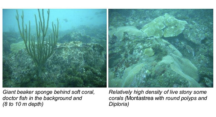
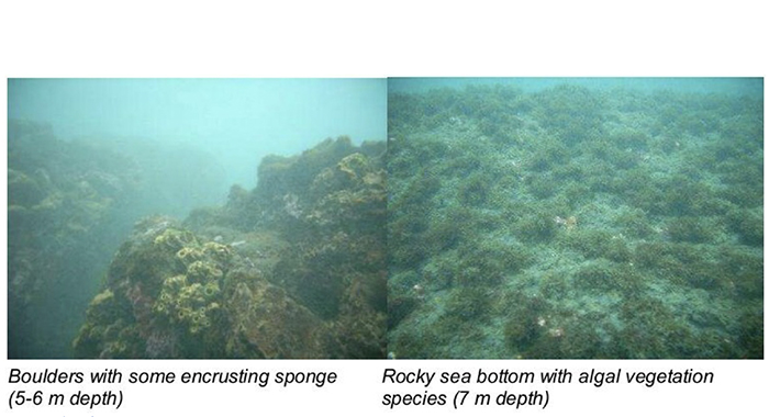
Enter the environmental impact assessment study that was done for the airport construction. This is a report done in 2008 by Knocks Consultants out of Germany. Under the subheading Marine Habitats and Wildlife, it summarises findings of the underwater area between the Yambou river mouth and the north end of the runway, as well as the other southern area between the river and Mt Coke.
In the northern section, it speaks to the existence of a reef, and mixture of boulders, pebbles, and sand as well as corals. It says: “Large individual sponges, growing on the bottom, were noticed also as well as crust-forming sponges”. Before listing over 16 species of fish, as well as lobsters, that were observed in the area, the report says: “Fish life was abundant, albeit small specimens of ornamental and food fish varieties”. Further it says: “Adult spiny lobsters were observed at various spots.”
The report also states that in this northern area, “rocky outcrops and boulders were found down to a depth of 12m, after which a sandy shelf area was found.”

The report also indicated the presence of reefs being in and around the Mt. Coke and Mt. Pleasant area, including in the line of approach to the runway. It states that the area south of the Yambou river mouth — unlike the northern area reef — had more algae and “found to be of less biological importance”. It goes on to state that in this area, “rocky outcrops were not found deeper than approximately 7 m, after which the black sand shelf started”.
In both areas, the report has indicated the presence of a “sand shelf”. Does this confirm what Simmons is referring to when he spoke of a sand barrier? If so, what does this mean when it is dredged?
Furthermore, the report states that “the presence of lobsters on these reefs in the relatively shallow part of the island shelf may continue to form the backbone of a lobster-pot fishery in the deeper part of the island shelf between 30 and 60m depth”.
What impact will dredging have on these reefs, and by extension, the lobster population in the area?
About turtles — including those with international conversation status — the report pointed to the local Fisheries Department as indicating that the beaches in the areas studied represent turtle nesting sites. That’s the area stretching from Stubbs to Peruvian vale.
Since the Knocks report is from 2008, it is fair for one to ask if and how the conditions in the area have changed since, but the fact that it is being dredged now may serve as an indication of its current condition, one way or the other. We’ve given you enough for thought, and again, we ask what exactly is the impact of dredging this area, all things considered?
As usual, we continue to encourage you to pay close attention to your affairs.
The opinions presented in this content belong to the author and may not necessarily reflect the perspectives or editorial stance of iWitness News. Opinion pieces can be submitted to [email protected].


So much could have happened in 15 years, yet our environmentally conscious administration did not see the need to commission a new environmental impact study prior to agreeing to the dredging. Of course there are 20 million reasons why.
Observer’s advice that we should “pay close attention to your affairs,” is solid advice and should be applied not only here but across the board to all things. The tacit suggestion in that is to hold whoever is responsible to account. Regrettably, too many of us are satisfied by lumber, galvanize, and cement every five years—the only time it matters when, after paying attention you do not like what you see. Then solid advice is for nought.
Sand reefs in the sea are not constant. They move with water currents. The analysis is flawed.
Dredged sea sand should never be used in cement because its salt content halves the life of the cement end product or application. Sea sand can be used if washed through a proper freshwater washing plant. The sand should be analysed after washing to determine if the salt content has been removed. There are UN directives asking governments not to dredge for sea sand. If dredged sand is used unwashed, besides shortening the life of the cement, it also attacks the steel reinforcing bars used in strengthening concrete products and applications. Thus the rusting re-bars expand and split and destroy the surfaces of concrete applications within a few short years. Almost everyone in Saint Vincent has seen blown surfaces on concrete columns that used sea sand, it is already a nationwide problem. If the intent is to dredge, it should only occur in ports and harbours to clean up silting. Dredging in the sea around the airport will cause seabed damage and destroy nature and is irresponsible. As far as using volcanic materials instead of or as an additive to cement is in fact a well know procedure and there are hundreds of Google pages on the very subject. The problem with SVG is that there are many know nothing people in charge of ministries with absolutely no knowledge of the subject in which they act or speak. I think this is exactly one of those times and unless SVG wakes up it will cost the nation dearly. I am sure one or two million are already wasted on this matter and will be cumulative when things start to fall apart in ten years time.
I’ve spear fishing some of these areas before and still but only on calm days and I can tell that boat is killing a lot a lot of lobsters.by now no lobsters wouldn’t be around warracou straight down to milligan cay
Is it possible that without a barrier the waves would be huge and come further inland to engulf the airport?
It was rumoured that the previous Kingstown port construction has some effect on beaches like Jackson Bay where there was a wide beach area where we played cricket and soccer. Now the water has moved inland and covers the entire beach.