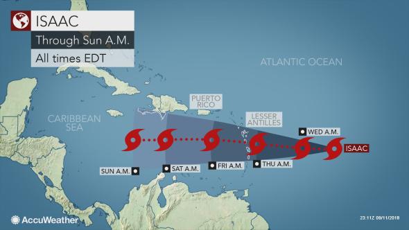
Forecasters in St. Vincent and the Grenadines will continue to monitor overnight Tuesday tropical cyclone Isaac, which has been downgraded from a hurricane to a tropical storm
The SVG Meteorological Services said Tuesday evening Tropical Storm Isaac was located east of the Lesser Antilles.
At 5 p.m. Tropical Storm Isaac was centred near latitude 14.6 degrees North; longitude 51.3 degrees West or about 670 miles (1,075 km) east northeast of SVG.
Maximum sustained winds remain near 70 mph or 110 km/h with higher gusts. Tropical-storm-force winds extend outward 105 miles (165 km) from the centre. Isaac continues to move westward at 17 mph (28 km/h).
On the current forecast track, the centre of this system is forecast to pass near Dominica, or approximately 150 miles (240 km) north of St. Vincent by early Thursday.
However, by early Thursday, an outer band associated with Isaac could result in some showers and possible isolated thunderstorm across our islands.
As the system progresses westward, an increase in moderate to heavy showers and occasional gusty winds can be expected from Thursday and into Friday. Forecast models suggest that rainfall accumulations of 50 to 75 mm (2 to 3 inches) are possible during the passage of Isaac.
Sea conditions are also forecast to deteriorate from late Wednesday with swells peaking near 3.5 meters or 11 feet.
A small-craft warning comes into effect at 6 p.m., Wednesday.
The St Vincent and the Grenadines Meteorological Services says it will continue to monitor this system and provide the necessary updates and/or advisories.
At this time, there are no watches or warnings in effect for SVG.


While they technically are cyclones, in the Atlantic they’re referred to as Hurricanes. Calling it cyclone Isaac when everyone else is saying hurricane Isaac is confusing. https://oceanservice.noaa.gov/facts/cyclone.html